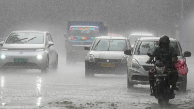

NEW DELHI: Two western disturbances in quick succession are likely to affect north-west India this week with peak activity on April 7-8, resulting in below normal to near normal day temperatures over the region and a wet spell, India Meteorological Department (IMD) said on Sunday. Western disturbance (WD) is an extratropical cyclone, originating in the Mediterranean region, that brings sudden rains and snow to the northern parts of the Indian subcontinent.IMD further said day temperatures are likely to remain below normal to near normal over most parts of the country during the next seven days due to various weather phenomena in different parts, ranging from WD in north-west, cyclonic circulation over west central Bay of Bengal off south coastal Andhra Pradesh in lower tropospheric levels to an upper-air cyclonic circulation over Rayalaseema and a trough running from this upper-air cyclonic circulation to Gulf of Mannar.These factors will result in wet spell activity with thunderstorm and lightning over central, east and peninsular India till April 9. States which may face such weather include Chhattisgarh, Madhya Pradesh, sub-Himalayan West Bengal and Sikkim, Bihar and Jharkhand.The India Meteorological Department said maximum (day) temperatures would rise by 2-4 degrees Celsius over north-west India till April 6 but “gradual fall by 2-4 degrees” on April 7-8, and “gradual rise by 2-4 degrees” during April 9-11.