Typhoon Sinlaku — the strongest tropical cyclone on Earth this year — relentlessly struck a pair of remote U.S. islands in the western Pacific Ocean early Wednesday local time with extremely powerful winds and heavy rain, with residents reporting tin roofs being torn apart.
The typhoon had sustained winds of up to 150 mph, equating to a strong Category 4, when it hit the islands of Tinian and Saipan of the Northern Mariana Islands, according to the National Weather Service. As of 11 a.m. Wednesday local time, maximum sustained winds had dropped to 130 mph and the storm started tracking to the north. Sinlaku is forecast to continue weakening through the next few days, the National Weather Service said, passing west of the islands of Alamagan, Pagan and Agrihan through the latter half of the week.
“I’m guessing anything that was made of wood and tin did not survive this,” Glen Hunter told The Associated Press. Hunter grew up on Saipan and watched at least three tin roofs fly past his yard.
Hunter, who has weathered numerous typhoons, told The AP this felt like the strongest yet. Rain was seeping into every crevice of his concrete home, he said.
“It was a losing battle because the rain was coming through everywhere,” he said. “Every house is just flooded with water, no matter what type of structure you’re in.”
Glen Hunter/AP 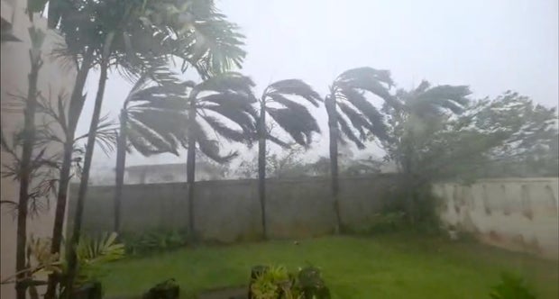
Extensive flooding was reported in certain places, with Saipan Mayor Ramon “RB” Jose Blas Camacho telling The Associated Press that Sinlaku was “hitting us hard.”
“It’s so difficult for us to respond with this heavy rain, heavy wind to rescue people,” the mayor said. “Objects are just flying left and right.”
Camacho told The AP some people have been rescued, while the typhoon toppled trees and caused wooden and tin structures to collapse.
Video shared by AP ahead of the typhoon’s arrival showed its early impacts on Saipan, as Sinlaku hovered offshore, launching fierce winds and rain toward the island. Before arriving on land, the storm had become “nearly stationary” about 30 miles off the coast of the archipelago for several hours, forecasts showed. Its slow pace raised concerns about how long the storm would linger in the region, and the amount of damage that could cause.
Nikki Nolan/CBS News 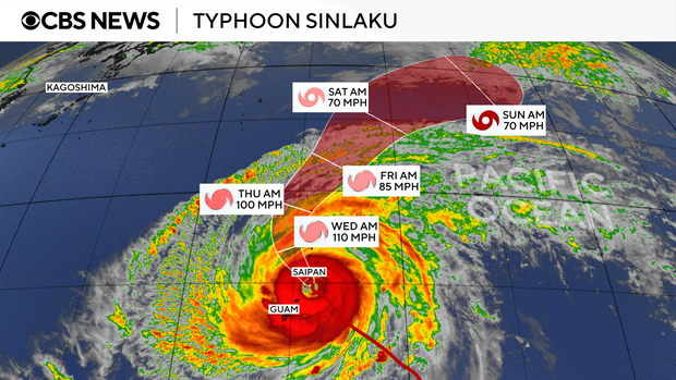
Tropical force winds and torrential rainfall led to flash flooding on Guam, a U.S. territory home to three U.S. military bases and about 170,000 people. Wind gusts peaked at 88 mph Tuesday night local time on the island — with consistent wind gusts between 70 and 80 mph recorded through the night, according to the National Weather Service. Tropical-storm-force winds were forecast to continue through Wednesday afternoon, according to Guam’s Joint Information Center.
“Even though the closest point of approach has passed, damaging winds will persist across the island, posing ongoing risks to public safety, infrastructure, and power lines,” the center said in an advisory, which urged people to remain indoors and out of the water.
The Guam Department of Education closed schools Tuesday and Wednesday, and the information center said they would remain shut until the governor declares conditions are safe for classes to return. The center also said Guam’s water authority was “aware of multiple power outages throughout the island as a result of the super typhoon.”
NOAA via AP 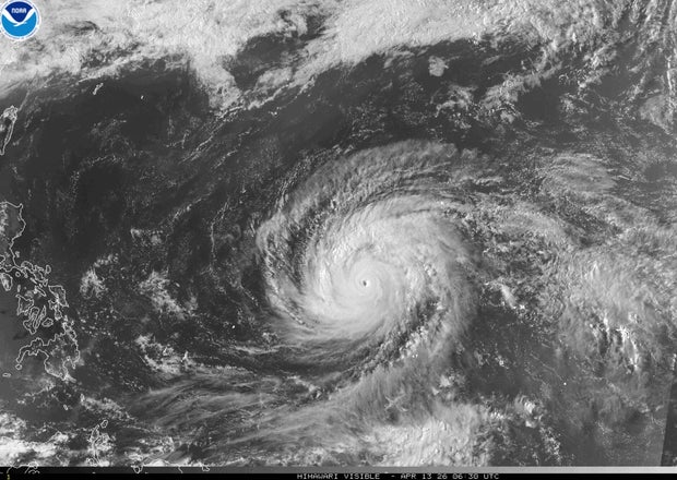
Typhoon warnings remained in effect for the Marianas islands of Rota, Tinian, Saipan, Alamagan, Pagan and Agrihan as of Tuesday evening, according to the weather service. Guam remained under a tropical storm warning and typhoon watch, the weather service said.
In the Southwest Pacific, “typhoon” is used to describe a tropical storm that forecasters would call a hurricane in the U.S. When a typhoon’s maximum sustained winds rise above 150 mph, it becomes a “super typhoon.”
Sinlaku’s maximum wind speeds peaked at 180 mph as the typhoon traveled over the open ocean on Sunday, making it the most powerful storm to develop so far this year, after typhoons Narelle and Dudzai.
On Sunday, President Trump approved emergency disaster declarations ahead of the forecasted storm for Guam and the Mariana Islands.
In May 2023, Super Typhoon Mawar struck Guam as a powerful Category 4 storm, hitting the island with destructive and powerful winds and heavy rain. In Saipan, the largest of the Northern Mariana Islands, residents are still recovering from the 2018 Super Typhoon Yutu and the economy has yet to rebound, Hunter told AP.
Eyewall replacement exhausted typhoon
Before its strength began to dip, Sinlaku was so intense as a super typhoon that it underwent an eyewall replacement cycle, said CBS News meteorologist Nikki Nolan. Radar data show the phenomenon happened sometime in the last 24 hours, while the then-super typhoon tracked toward the Marianas.
Eyewall replacement cycles are often seen in the mightiest tropical storms. In the case of Sinlaku, a new eyewall formed around the original one, prompting the original to collapse on itself and grow in size. Nolan said this was the typhoon’s “way of burning itself out,” and the process caused it to slow down and drop to a Category 4 storm.